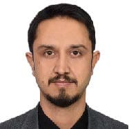
Ahmad Qasim Akbar is an Afghan geoscientist with over a decade of professional and academic experience in geology, GIS, remote sensing, and geo-disaster prevention. Born in Kabul in 1989, he has built an international career spanning Afghanistan, Japan, and Germany, contributing to both scientific research and applied geoscience projects.
Currently, Ahmad works as a Geoscientist at the Federal Company for Radioactive Waste Disposal (BGE) in Germany, where he specializes in the acquisition, processing, and interpretation of geoscientific data related to sedimentary host rock sequences. His work focuses on the integration of seismic, borehole, and petrophysical data into advanced 2D and 3D geological models. He also contributes to developing assessment methodologies for nuclear waste management in accordance with German law and regularly presents his findings at both scientific and public forums.
Alongside his professional role, Ahmad is pursuing a Ph.D. in Civil Engineering at Kyushu University, Japan, where his research centers on geo-disaster prevention, debris flow modeling, and landslide hazard assessment. He previously earned his Master’s degree in Civil and Structural Engineering from the same university (2018), following a Bachelor’s degree in Exploration Geology from Kabul Polytechnic University (2011).
Ahmad’s earlier career includes senior positions at the Ministry of Mines and Petroleum in Afghanistan, where he directed the Geological Information and GIS/Remote Sensing departments, overseeing teams of up to 44 professionals. In these roles, he managed large-scale geological mapping projects, developed mineral information packages, led mineral exploration initiatives, and provided technical advice on mining contracts and geospatial policy. He has also collaborated with international organizations such as the World Bank, GIZ, and the Afghanistan Geological Survey, contributing to projects on mineral governance, data management, and exploration.
His academic contributions are widely recognized, with publications in leading journals such as Geosciences and Water. His recent research includes the integration of statistical methods for regional landslide hazard mapping, the development of new approaches for debris flow runout assessment, and the evaluation of DEM resolution impacts on hazard modeling. He has also co-authored USGS reports on lithium exploration and geophysical modeling in Afghanistan’s Panjshir region and presented his work at several international conferences.
Beyond his professional and academic commitments, Ahmad has contributed to education as a thesis advisor at Kabul Polytechnic University and has served as a student representative at Kyushu University. He is multilingual—fluent in Persian, English, and Pashto—with working proficiency in Urdu and German.
Ahmad brings to any team not only deep technical expertise in geoscience and remote sensing but also a strong international perspective, having worked across diverse environments and institutions. His mission is to combine scientific innovation with practical solutions for natural resource management, environmental safety, and disaster risk reduction.
